


Seven Years of Colourful Maps

In October 2016, Robert uploaded some of the maps he had created in his spare time to Reddit and Imgur. People seemed to like them; no one had ever seen rivers illustrated in such an eye-catching and informative way before. Within a few days, the colourful river basin maps had gone viral. The original post received 90,000 views in a few days, with many reposts on Imgur alone boasting similar numbers. Due to popular demand, he opened his first webshop the following week.
Seven years later, we have many amazing achievements behind us, including exhibitions, talks, and dozens of collaborations with international organisations. Hundreds of articles have been written about Robert's unique map styles, and more than ten thousand maps have been sold as wall art and digital files. But most importantly, our maps have helped millions of people understand the importance of freshwater and how we are all connected by river systems.
We are forever grateful to everyone who has supported us on our journey, whether by buying our maps, regularly sharing our posts on social media, or simply reading our blog. But we also appreciate the silent supporters who have talked about us to a colleague, bought us a coffee, liked one of our posts or read one of our blog posts. You are all the reason we can still do what we love. We really hope to be here with you for at least another seven years.
Thank you for being awesome and for supporting us. Let's make the world a better place with colourful maps!
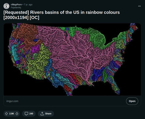
How it all started: the first US river basin map in a Reddit post from 2016.
Leave a comment